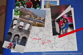
When I was preparing geography lessons for Mavi years ago, I learned about the importance of Geography Folders. Essentially, these are folders filled with pictures from your home country or continent as well as from other continents. The pictures should depict people engaging in daily life activities, landmarks, food, animals, children, homes, transportation, and villages, if any. Geography Folders are especially useful for studying your continent as they introduce your child to other races, cultures, places, and traditions.

Experiencing different continents and cultures through travel is still considered the best way to learn. There is nothing like taking long flights, spending layovers in airports, seeing people of different races, hearing different languages, trying exotic foods, experiencing different cultures and climates, and observing various structures. Fortunately, we get to travel annually to Asia or the United States to visit our families, which has accelerated our knowledge of maps, flags, and topographies, and has sparked our interest in learning about other cultures and religions.
The Geography Folder contains photos that support these learnings and interests. For instance, my early "Geography Folder" for Asia comprises the following pictures.:

I printed these pictures and made Mavi assemble the folder to look like an album so we can explore it anytime. As you can see, we added a description for each of the photos.


Then these Geography Folders evolved into real photos of our travel kept in a folder. The boys can immediately relate to these photos because they are in them. And the miniature landmarks figures (Safari Ltd Around the World TOOB and Safari Ltd World Landmarks TOOB) that we own also helped in learning about places.

A few years ago, I came up with a new type of Geography Folder that would suit both my older child and preschooler. I created our Nutshell Series, which features important facts and information about each continent. Here's a sample of our Africa fact cards from Africa in a Nutshell. The cards are ideal for my elder child to read, and they make great companions while traveling.

For more information about our Nutshell series, click any of the images below.
Vito's Geography Folders contain traditional pictures with short descriptions. However, I compiled these pictures into a photo album format. Of course, if required, the photos can still be detached from the binder. Please note that these photos are not part of the Nutshell series and can be purchased from the shop.
Simply click on the images below to buy them
We utilized the Geography Folders which contained maps. For Vito, I would carefully go through one photograph at a time and connect it to the map or the corresponding puzzle piece if we were using the Montessori continent map puzzle. For Mavi, we opted for puzzle pieces of countries from our Asia or Europe Montessori maps. Sometimes, I would also incorporate objects related to the photo, such as (1) figures of renowned landmarks from our Safari Toob collection and (2) souvenir items. To see how we applied these materials, you can check out our Asia for Preschoolers post.

And that’s about it! Happy learning!
Pin this for later!
This post is part of the 12 Months More of Montessori which is hosted by Natural Beach Living and The Natural Homeschool.
Amazing blogs participating in the 12 Months More of Montessori that you should visit:
20+ Ways to Teach Montessori Geography Kids Will Love | Natural Beach Living
North America for Kids - Printable Geography 3-Part Cards | The Natural Homeschool
The Ultimate Guide to Montessori-Inspired Geography Activities for Preschoolers | Living Montessori Now
Montessori Animals and Continents with Printable | Mama’s Happy Hive
Our Favorite Geography DIYs | The Kavanaugh Report
Montessori Geography Folders | The Pinay Homeschooler
Introduction to Russia Printables | Welcome to Mommyhood
Montessori Primary Geography Checklist | Sugar, Spice & Glitter


Wow! Full disclosure: I'm a geography teacher :) These are great!
ReplyDelete